• NEW! LOWEST RATES EVER -- SUPPORT THE SHOW AND ENJOY THE VERY BEST PREMIUM PARACAST EXPERIENCE! Welcome to The Paracast+, eight years young! For a low subscription fee, you can download the ad-free version of The Paracast and the exclusive, member-only, After The Paracast bonus podcast, featuring color commentary, exclusive interviews, the continuation of interviews that began on the main episode of The Paracast. We also offer lifetime memberships! Flash! Take advantage of our lowest rates ever! Act now! It's easier than ever to susbcribe! You can sign up right here!

    Subscribe to The Paracast Newsletter!

crazy contrails

Free episodes:

Wade

FeralNormal master
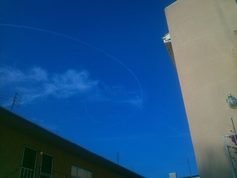
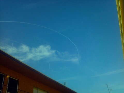
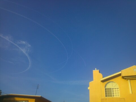
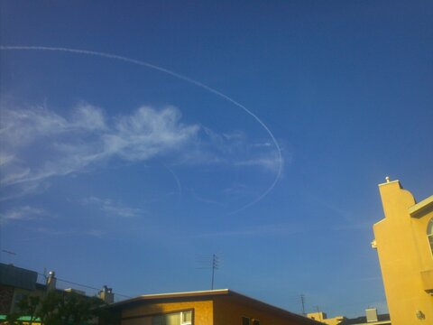
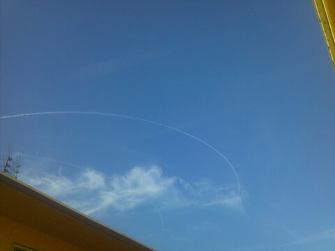
a few days ago on the 18th i was out on the patio enjoying the lovely southern california morning at 7:30 in the morning it was one of those days where there was some high cirrus type clouds and hence some contrails from some passing jets could be seen.

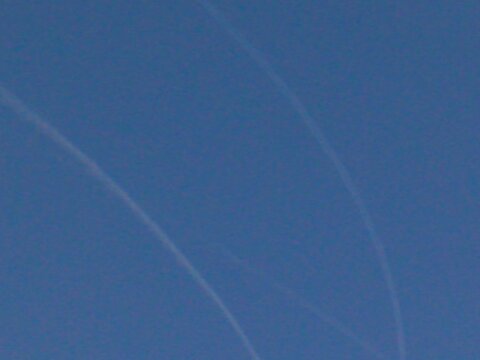
i just happened to look up and i noticed the remnents of a contrail of a jet that had done a 180 degree turn like it had forgotten it's lunch or something and turned around back to get it. A few minutes later i saw another jet/contrail streaking overhead and it started to change course, i told myself "i'll bet its going to do the same thing"...sure enough it did. A couple of minutes later one more appeared and did the same thing and after that , no less than 3 jets did the same maneuver (sp?). at the time i did have my phone so i snapped a few pics, the resolution isn't very good but on one of them if you look real closely you can make out four (picture #5) currently forming contrails.

all together i witnessed about 9 passes in the space of about 15 minutes, i don't know how many jets were involved and for all i know they could have been 9 seperate jets taking off and turning around or about 4 jets doing 360's in the morning sky. furthurmore on at least 2 of the passes i viewed with my binocs for what i could swear was a red underbelly or colors similar to a southwest airlines jet, considering the seemingly tight formation on pic number 5 i would have thought they were military jets maybe from miramar to the south but a couple of them did seem big, more like tankers or civilian craft. from my vantage point in west la i would say that the jets were over land and due directly south


i assumed maybe the turn around was because they were at a point of encroaching on lax airspace for departing craft over the ocean but they seemed to be too high for that. at any rate i had never witnessed "behavior" like that from any craft, it seems to me if they were from a naval base they would try any maneuvers (again sp?) towards the san diego county desert to the east and not over ocean where arriving jets from the east come through. anybody got an ideas?
 

Attachments

  • 1.jpg
    1.jpg
    120.5 KB · Views: 19
  • 2.jpg
    2.jpg
    139.4 KB · Views: 21
  • 3.jpg
    3.jpg
    86.3 KB · Views: 19
  • 4.jpg
    4.jpg
    138.6 KB · Views: 20
  • 5.jpg
    5.jpg
    114 KB · Views: 20
  • 6.jpg
    6.jpg
    120.8 KB · Views: 19
  • 7.jpg
    7.jpg
    108.1 KB · Views: 14
Could it have been cos of a delay that the jets were put into a 'holding pattern' ? I have had to circle London quite a few times and watched multiple other planes doing the same due to a thunderstorm over Heathrow airport.
Of course, local knowledge is often key and if you say you find this behaviour is unfamiliar for where you live - then that is good enough for me. If it's weird, it's weird. Regardless, good on you for taking phots, and posting them for discussion.
 
Could it have been cos of a delay that the jets were put into a 'holding pattern' ? I have had to circle London quite a few times and watched multiple other planes doing the same due to a thunderstorm over Heathrow airport.

That's actually a very good answer and one so simple I didn't even think of it. Maybe the right answer. there was nothing going on meteorlogically at the time but I suppose something could have happened so that all the slots were full.. I actually have an app my android (airport delays) that could have told me that if I thought to look. I've lived in l.a. for over thirty years and west l.a. / santa monica for twenty of them and im quite familiar with the airport traffic. Im wondering if there are protocols for keeping planes in a holding pattern. These jets here were flying in a north south pattern and were high enough to leave a contrail (not sure at height one had to be for that but it did seem they could have been a hazard to the normal non-lax north south flights that I see all the time . I suppose they could have been traffic approaching from the east (hawaii, south pac flights,) and was told to hang out over the ocean until they got the all-clear to land.
 
I know there are a few people in this forum who are very familiar with aircraft rules and movements - someone will know whereabouts such a pattern would happen for LAX and at what height but I've no clue.
Just because it's an answer doesn't mean it is the correct answer though..
 
That's actually a very good answer and one so simple I didn't even think of it. Maybe the right answer. there was nothing going on meteorlogically at the time but I suppose something could have happened so that all the slots were full.. I actually have an app my android (airport delays) that could have told me that if I thought to look. I've lived in l.a. for over thirty years and west l.a. / santa monica for twenty of them and im quite familiar with the airport traffic. Im wondering if there are protocols for keeping planes in a holding pattern. These jets here were flying in a north south pattern and were high enough to leave a contrail (not sure at height one had to be for that but it did seem they could have been a hazard to the normal non-lax north south flights that I see all the time . I suppose they could have been traffic approaching from the east (hawaii, south pac flights,) and was told to hang out over the ocean until they got the all-clear to land.

If you message me your location I can look it up on my navigation program and see what airspace is around. I will say that SoCal, especially the LA and surrounding areas are super busy from an air traffic standpoint.

Alternatively, you can go to the following site and download a cool 3D extension to Google Earth for viewing airspace. You can then identify which airspace this guy was in and what airport controls it. Then you can find out what the normal holding patterns are. That is if you really want to take it that far. :)
 
If you message me your location I can look it up on my navigation program and see what airspace is around. I will say that SoCal, especially the LA and surrounding areas are super busy from an air traffic standpoint.

Will do. would I send my gps coords or a google maps link ?
 
I've seen the 180 deg maneuver like this once before, and it does look puzzling. I wouldn't read too much into it. The skies are crowded nowadays, and "stuff" happens. And military exercises are another possibility.
 
fwiw Boomer, in the intervening years with the use of an app on my phone and observing traffic these planes were probably at 34k feet and that is the approx height of planes leaving John Wayne airport down in Orange County although these would have been over the ocean when most flights departing from John Wayne are directly overhead me. Their location is more indicative of flights from San Diego but those flights are usually at 37k + feet by time they get to me. At any rate There wouldn't have been any danger to traffic taking off from LAX as those flights would be well below 10K feet but in the same "vertical " airspace.

And at 34k feet I don't think they would have been in any holding pattern for any airport. 34k is pretty much cruising attitude.
 
Last edited:
fwiw Boomer, in the intervening years with the use of an app on my phone and observing traffic these planes were probably at 34k feet and that is the approx height of planes leaving John Wayne airport down in Orange County although these would have been over the ocean when most flights departing from John Wayne are directly overhead me. Their location is more indicative of flights from San Diego but those flights are usually at 37k + feet by time they get to me. At any rate There wouldn't have been any danger to traffic taking off from LAX as those flights would be well below 10K feet but in the same "vertical " airspace.

And at 34k feet I don't think they would have been in any holding pattern for any airport. 34k is pretty much cruising attitude.

Good points.
 
Here's One - I figure it's a rocket launch out of Argentina.
Still interesting though


The video afterwards looks like a parallax
effect of a sunrise or sunset
in the distance.
 
Here's One - I figure it's a rocket launch out of Argentina.
Still interesting though


The video afterwards looks like a parallax
effect of a sunrise or sunset
in the distance.
Secureteam10? Have you lost your marbles? We are talking about the number 2 source of hoaxes behind 3rd phase

Sent from my SM-J327V using Tapatalk
 
Secureteam10? Have you lost your marbles? We are talking about the number 2 source of hoaxes behind 3rd phase
There's no question a lot of the content from both the sources you mention is just noise, but I'm not certain either of them hoax videos themselves or that it's all just noise. I did a little checking into the cloud coverage overlay for Google Earth and according to those sources, the clouds are made from actual satellite cloud coverage data, meaning they're not actual visual images, but the data used to create the images is from real satellite sensors. There was also another site with stills of the same trail ... Local Guides Connect - Google Maps Satellite view straight line cloud.

So in this case either the Secureteam guy created a fake 3D earth rendering that works like Google Earth and put a fake cloud trail into it, plus created another fake post on another website with stills just in case anyone wanted to check around, and then created the fake YouTube video, or it's an actual video of him using Google Earth to show us this strange cloud. If it's a hoax, I'd like to see more evidence of that before offhandedly dismissing it simply because other stuff is obviously not as advertised.


In the meantime I'm not saying one way or another with definitive certainty whether it's real or not. Bur checking around to see what might have been the cause, it turns out that there is an actual spaceport in Argentina at about where that cloud starts ( it doesn't actually start in Antarctica ). It therefore might be a contrail from a rocket launch. Or, as you suggest, it could be a hoax. I'm just not the one to say for sure at this point, and found it interesting enough to post.
 
Last edited:
Back
Top