I have a question:
Do you keep a record of all of the precise coordinates of each interesting image?
There are many reasons I think it would be a good idea, these mainly are:
#1 a new mission could be launched in the future with even better equipment and getting comparison pictures would great, and
#2 it would be possible for other people to use one of your finds to search around its specific area using the imagery available now.
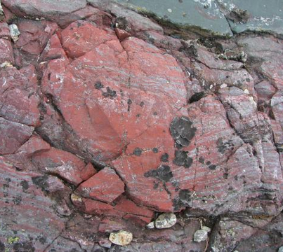
First let me say that I am still an amateur in capturing and reproducing anomalies visible in the Mars photo imagery. I've been following the subject for only about 14 months and searching out, cropping, and enhancing specific anomalies for a year. Most of the data I study is that which appears in the searchable gigapans produced from releases of JPL's panoramic rover photographs. I linked above to a long list of 'PDS gigapans' based on JPL's later-released versions of these panoramas that provide improved visual precision over the originally released raw images. Until those PDS images are available, skilled image researchers work from the raw data, before two 'takes' from whatever rover camera has been used (there are 15 or so on Curiosity) are superimposed to sharpen the raw image. The PDS images are the best data to use, but it is often many months before they are produced and released. In the meantime image researchers work with raw data released in single batches that are not complete and not searchable until the total data is released as a panorama and made searchable in gigapans produced by private researchers such as Neville Thompson and Keith Laney. Image researchers also work with satellite imagery obtained by several JPL satellites (and also an ESA satellite) orbiting Mars. Areas of interest photographed by the rovers are often re-imaged from one of these satellites. Below is an interesting anomaly obtained from one of those satellite images (referred to as PIAs) by Neville Thompson.

The above anomaly was discovered and cropped from this source:
HiRISE | Swirls of Rock in Candor Chasma (PSP_001984_1735)
{note: see the JPL notes at that link concerning water and geologic processes at this site}
I have not always attached the SOL identification or gigapan link to the individual cropped images I’ve worked with and stored in photobucket (though I did with the lizard anomaly I linked here [before you and
@marduk showed the image]. Right after my first link to that one I posted a link to the gigapan from which it was cropped. By searching that gigapan you can get a better idea of what image researchers have to work with in cropping out and enhancing objects showing up in the raw data.
There is an enormous amount of data available from panoramic photographs obtained by the three rovers – Spirit, Opportunity, and Curiosity – on Mars. Spirit, the first one, became inoperational at a point some years ago, but Curiosity is still moving around on the surface and sending photographic data after about six years.on Mars. Curiosity has been doing so for about the last three years. New imagery is obtained and released by Curiosity and Opportunity continually. No one person could study all of it, but there are by now numerous researchers at work analyzing the rover imagery, and many, many cropped and enhanced portions of these panoramic images are posted every day on the internet and especially by participants in a dozen or more groups active on facebook.
Curiosity has been at work in Gale Crater since it was landed there 3 years ago. Gale Crater [93 miles across] was selected as a site by NASA/JPL because it was known to have contained a deep lake and a two-mile-high mountain {Mt. Sharp} in its center. Curiosity has been traveling up that mountain for two years now, sending back panoramic images of many different kinds of terrain and also closeup images of stones, pebbles, etc., taken by its ‘ChemCam’, which is able to analyze various minerals in scooped-up materials drawn out of holes generated by a laser on the rover.
Finally, in my own research I’ve worked with both cropped areas from the gigapans or cropped images others have posted that I’ve attempted to make more visible by increasing the light, contrast, and hues latent in the images as released in the gigapans and sometimes in the very dark, flat, single raw images released before the panoramic take is released as a whole. The latter require far better imaging software than I have access to, but I’m sometimes able to enhance the visibility of the objects in the available data. When I post these in the FB forums I always identify the SOL data itself and the gigapan from which I’ve taken the cropped image, but I haven’t generally stored that information in transposing an enhanced image from my Microsoft image gallery to photobucket. It’s always possible however to track down that source by consulting with one of the seasoned experts posting Mars images in the FB forums over many years now.
As for getting JPL to send a rover back to a previously visited area to re-photograph it, that’s most unlikely (unless one or more of JPL’s own image analysts were to request it). It has happened in one or two cases I know of that a rover did pass by a particular area a second time in navigating the difficult terrain on Mr. Sharp and reimaged some objects from a different camera or camera angle. In one of these cases, it was clear that some objects laid out on a rock ledge had disappeared and been replaced within a matter of days between the two employments of the rover cameras.


